
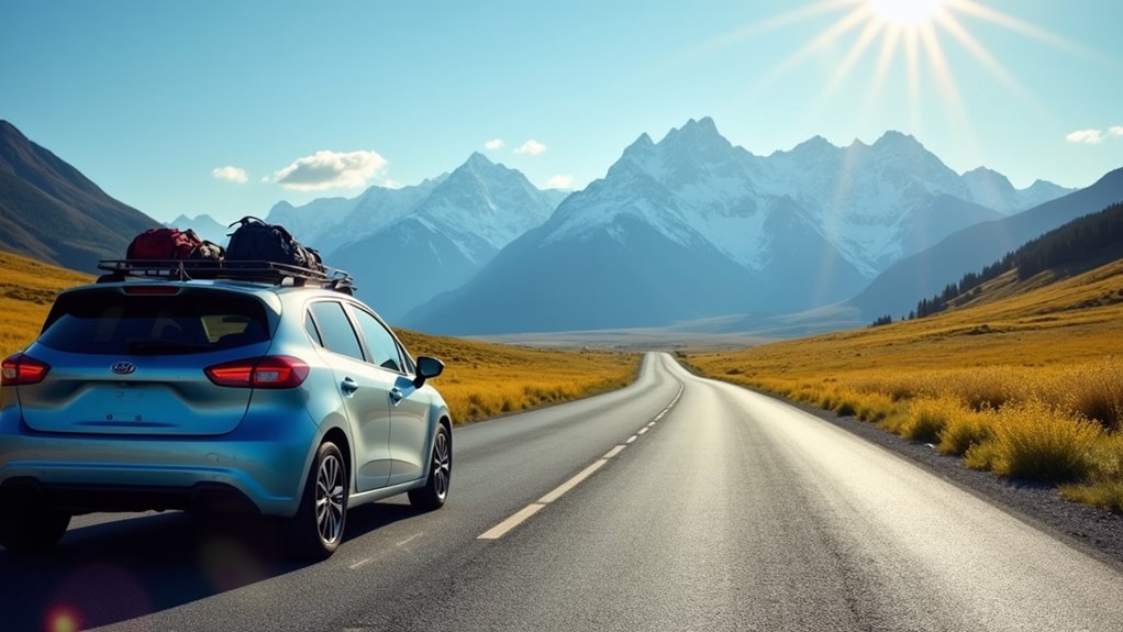
You’ll want to start with calm coastal routes like Navarre Beach, Florida, or well-maintained mountain roads in South Dakota’s Black Hills for confidence building. Classic Route 66 from Albuquerque to Amarillo offers straight highways great for practicing desert driving, while Grand Canyon’s rim drives provide scenic views with low-stress conditions. California’s Golden Gate Bridge to Lake Tahoe progression teaches city-to-mountain navigation, and Utah’s Zion to Lake Powell route offers manageable canyon country exploration with plenty of rest stops and guidance ahead.
- Navarre Beach, Florida: Calm Gulf Waters and Low-Traffic Coastal Routes
- Road to Hana, Maui, Hawaii: Scenic Curves and Confidence Building
- Black Hills, South Dakota: Western Adventure on Paved Mountain Roads
- Route 66: Albuquerque to Amarillo: Historic Highway With Desert Practice
- Grand Canyon National Park, Arizona: Rim Drives With Spectacular Views
- Redwood National and State Parks, California: Giant Trees and Peaceful Park Roads
- Golden Gate Bridge and Lake Tahoe, California: City Exits to Scenic Mountain Drives
- Death Valley National Park, California: Desert Roads and Ranger-Guided Routes
- Valley of Fire State Park, Nevada: America’s Most Scenic Desert Loop
- Zion National Park to Lake Powell, Utah: Canyon Country With Rest Day Flexibility
- The Sum Up
Navarre Beach, Florida: Calm Gulf Waters and Low-Traffic Coastal Routes
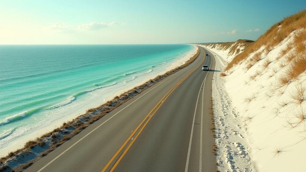
When you’re looking for a destination that builds confidence behind the wheel, Navarre Beach offers exactly what teen drivers need: calm waters and stress-free coastal roads. Located on Santa Rosa Island, you’ll navigate simple, linear routes instead of confusing intersections.
The main approach via Navarre Beach Causeway (FL 399) connects directly from US 98, eliminating complex urban driving.
You’ll find emerald-green Gulf waters great for swimming and snorkeling, while Santa Rosa Sound provides even calmer conditions for kayaking.
The 1,545-foot fishing pier, Marine Park, and Sea Turtle Conservation Center cluster together, reducing driving between activities. The compact area makes navigation particularly easy since it’s walking-friendly and allows for bike rentals as alternative transportation options.
This area markets itself as “Florida’s Most Relaxing Place,” reflecting lighter traffic compared to busy Destin or Pensacola Beach.
The undeveloped shoreline and nearby Gulf Islands National Seashore offer peaceful practice opportunities.
Road to Hana, Maui, Hawaii: Scenic Curves and Confidence Building
While Navarre Beach offers straight coastal roads for building basic skills, Hawaii’s Road to Hana presents a completely different challenge that can transform nervous drivers into confident navigators. This 52-mile stretch features over 600 curves and 59 bridges, forcing you to master controlled turning at 25 mph speeds.
You’ll develop essential skills like honking before blind curves, yielding on one-lane bridges, and maintaining safe following distances.
However, this isn’t a casual drive. The road’s ranked among the world’s most dangerous, with increasing fatalities from distracted travelers. You’ll need constant attention—no scenic gazing while driving. Sudden weather changes, including rain, can impact visibility and safety requiring even more caution from inexperienced drivers.
Avoid night driving due to poor lighting, and don’t attempt racing locals who know every curve. When approached properly with caution and respect, the Road to Hana builds invaluable driving confidence through controlled, challenging conditions.
Black Hills, South Dakota: Western Adventure on Paved Mountain Roads
After mastering Hawaii’s tight curves, South Dakota’s Black Hills offer teen drivers a chance to tackle genuine mountain terrain without the extreme risks of alpine passes. You’ll find U.S. Highway 385 serves as your main north-south backbone, connecting Mount Rushmore and scenic side routes across 5,000 square miles of mountains.
The state’s road network provides excellent conditions for learning—asphalt pavements average just 9.3 years old, and South Dakota DOT maintains 26% of the system annually.
You’ll encounter manageable grades and curves while building confidence on well-maintained surfaces. For navigation practice, teen drivers can learn to identify the brown road signs that mark forest service routes throughout the Black Hills region.
Choose lighter-traffic scenic routes over heavy-truck corridors, and you’ll experience genuine western mountain driving with modern safety features. The ongoing $72 million highway improvements demonstrate the state’s commitment to driver safety.
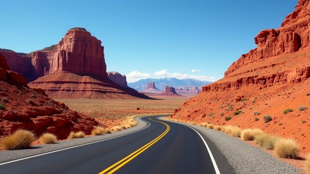
Route 66: Albuquerque to Amarillo: Historic Highway With Desert Practice
Though Route 66 no longer appears on modern maps as a continuous highway, the Albuquerque-to-Amarillo stretch offers teen drivers an ideal introduction to desert conditions with manageable 290-mile segments and multiple practice options.
You’ll experience straight, wide highways with excellent visibility as terrain shifts from New Mexico’s high desert to Texas Panhandle plains. The 4.5-hour drive includes frequent small towns like Tucumcari and Santa Rosa for fuel stops and short practice hops.
Historic attractions provide safe stopping points, including Glenrio’s ghost town and the official Route 66 midpoint marker in Adrian, Texas. Teen drivers can stop at the Midpoint Cafe, which has operated continuously since 1928 as the oldest eatery on Texas Route 66.
You’ll practice elevation changes, crosswind steering control, and adapting to desert glare while experiencing classic Americana along preserved segments of America’s most famous highway.
Grand Canyon National Park, Arizona: Rim Drives With Spectacular Views
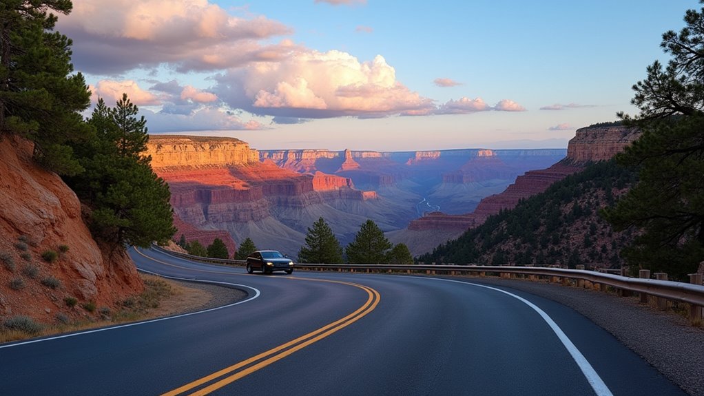
Moving from desert highways to mountain terrain, Grand Canyon National Park’s rim drives provide teen drivers with 35 miles of paved roads that showcase America’s most iconic natural wonder while offering low-stress driving practice. You’ll navigate well-maintained routes like Desert View Drive, which features multiple scenic overlooks great for building confidence behind the wheel.
The park’s shuttle system handles most congestion with over 5 million annual boardings, reducing traffic stress for new drivers.
Safety remains paramount here—while the park sees nearly 5 million visitors yearly, vehicle crashes rank low among incident causes. When stopping for photos, always stay on designated viewing areas to avoid the unstable rim edges that can crumble unexpectedly.
You’ll access the South Rim via US Routes 180 and 64 from Flagstaff, experiencing diverse terrain from pine mountains to desert basin.
These rim drives offer spectacular photography opportunities while developing essential mountain driving skills.
Redwood National and State Parks, California: Giant Trees and Peaceful Park Roads
While towering redwoods create natural cathedrals along California’s coast, Redwood National and State Parks offer teen drivers 50 miles of diverse routes that range from beginner-friendly scenic parkways to challenging single-lane forest roads.
Start with Newton B. Drury Scenic Parkway, a 10-mile alternative to US-101 that’s great for new drivers. This low-speed, two-lane road bans commercial vehicles and encourages frequent stops among old-growth forests. You’ll likely spot Roosevelt elk in nearby meadows.
For ocean views, try short spur drives like Enderts Beach Road, which limit your exposure to highway speeds. Avoid Coastal Drive Loop initially—its steep grades and sharp curves challenge experienced drivers.
Skip Howland Hill Road and Davison Road until you’re comfortable with single-lane, unpaved conditions and stream crossings. Plan your fuel stops carefully since gas stations are scarce throughout the park areas.
Golden Gate Bridge and Lake Tahoe, California: City Exits to Scenic Mountain Drives
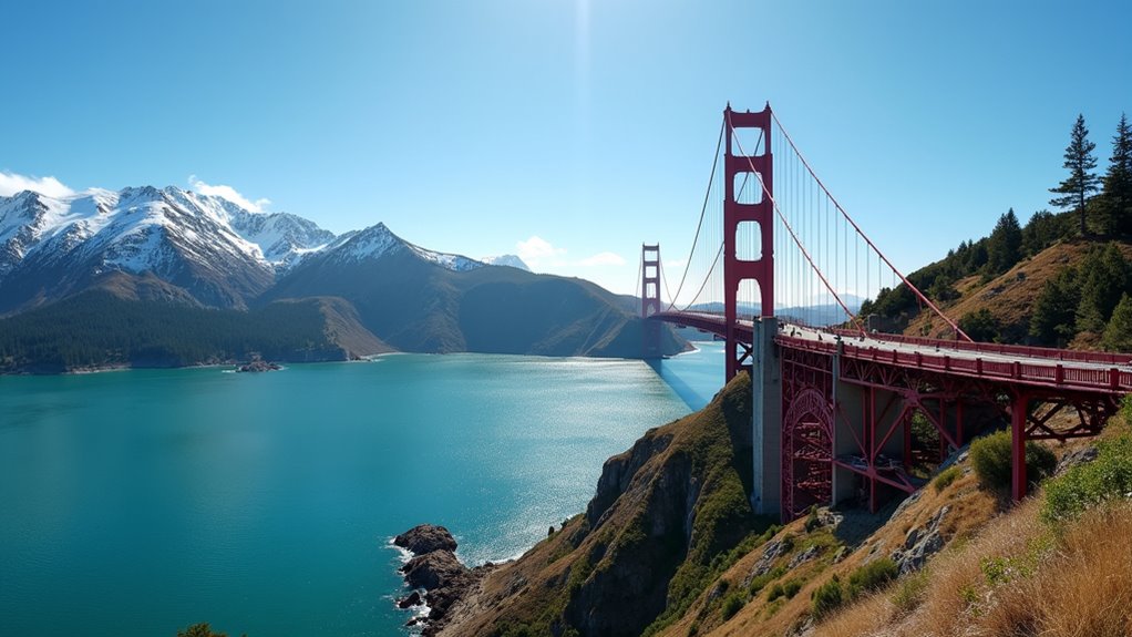
From San Francisco’s iconic Golden Gate Bridge to Lake Tahoe’s alpine scenery, this 200-mile journey gives teen drivers experience with urban exits, freeway guidance, and mountain driving—all while rewarding you with some of California’s most stunning landscapes.
You’ll start by crossing the 1.7-mile Golden Gate Bridge, then choose your route to Tahoe. I-80 East offers four lanes and easier driving for beginners, passing through Truckee before reaching the north shore. Highway 50 provides more challenge with narrower roads but incredible forest views through Eldorado National Forest.
Both routes teach essential skills: merging onto freeways, maintaining speed on inclines, and navigating mountain curves. Stop at Donner Memorial State Park or North Vista Point for breaks. Remember, I-80’s wider lanes make it the safer choice for new drivers. Consider booking a campervan rental in San Francisco for overnight camping options along this scenic route.
Death Valley National Park, California: Desert Roads and Ranger-Guided Routes
Unlike coastal mountain drives, Death Valley’s desert roads present unique challenges that’ll teach you heat management, fuel planning, and traversing extreme terrain. Start with Highway 190’s reliable paved sections connecting Panamint Springs to Furnace Creek. You’ll safely experience highlights like Artists Drive’s colorful loop and Zabriskie Point’s golden badlands views.
Stick to paved routes initially—save graded dirt roads like West Side Road for when you’ve gained experience with high-clearance vehicles. Never attempt 4WD backcountry routes like Steel Pass without expert skills and proper equipment.
Always carry extra water, gas, and tools. Check road conditions before departing, especially after rain when washouts occur. Summer heat can close roads entirely. Winter conditions may bring snow and ice that require tire chains for safe passage.
Death Valley’s unforgiving environment demands respect, but rewards careful drivers with unforgettable desert landscapes.
Valley of Fire State Park, Nevada: America’s Most Scenic Desert Loop
Just an hour from Las Vegas, Valley of Fire State Park offers teen drivers Nevada’s most accessible desert loop experience. The 3-mile Scenic Loop Road combines paved and gravel surfaces, great for building confidence on varied terrain.
You’ll navigate past red sandstone formations, natural arches, and beehives-shaped rocks while maintaining safe 25-35 mph speeds.
Key stops include Atlatl Rock’s petroglyphs and Arch Rock viewpoint—both requiring minimal walking. The compact road network lets you complete the full scenic drive in half a day with multiple picnic areas for breaks. For more adventurous drivers, the 5.7-mile White Domes Road provides an audacious ascent between tall red sandstone ridges with access to additional hiking trails.
Summer temperatures exceed 100°F, so pack extra water and check your vehicle beforehand. The park’s well-marked roads and developed facilities make it ideal for practicing desert driving skills safely.
Zion National Park to Lake Powell, Utah: Canyon Country With Rest Day Flexibility
When you’re ready to tackle Utah’s stunning canyon country, the 125-mile drive from Zion National Park to Lake Powell delivers America’s most spectacular desert scenery along U.S. Route 89. You’ll spend under 2.5 hours driving, leaving plenty of time for exploring without feeling rushed.
Start with Zion’s easy Riverside Walk, a 2-mile paved trail that’s great for building confidence. The park requires shuttle transportation during peak season, so plan accordingly.
From Mt. Carmel Junction, you’ll join scenic U.S. 89 toward Lake Powell. Consider stopping at Coral Pink Sand Dunes State Park for an optional ATV adventure along the way.
At Lake Powell, you can kayak 2.5 miles to slot canyons or take guided Antelope Canyon tours. Don’t miss Horseshoe Bend near Page—it’s just five minutes off your route and stunning at sunset.
This flexible itinerary lets you rest between activities.
The Sum Up
You’ll build confidence and skills on these carefully chosen routes that balance scenic beauty with manageable driving challenges. Remember to start with shorter distances, take frequent breaks, and always have an experienced driver accompany you. Don’t rush—these destinations aren’t going anywhere, but your safety matters most. Plan your routes during daylight hours, check weather conditions, and keep emergency supplies handy. Most importantly, enjoy the journey and celebrate each driving milestone you achieve.